You are here
Announcements
Recent blog posts
- Male Sex Trade Worker
- Communities resisting UK company's open pit coal mine
- THE ANARCHIC PLANET
- The Future Is Anarchy
- The Implosion Of Capitalism And The Nation-State
- Anarchy as the true reality
- Globalization of Anarchism (Anti-Capital)
- Making Music as Social Action: The Non-Profit Paradigm
- May the year 2007 be the beginning of the end of capitalism?
- The Future is Ours Anarchic
Surveillance Cameras in New York City's Lower East Side
SCP-New York writes "surveillance cameras in
Manhattan's Lower East Side
Our maps of the locations of surveillance cameras installed in public places in Manhattan were originally designed to find out and then show how many cameras are in operation, and to hazard educated guesses as to the owners of these cameras. But, if these maps are up-dated periodically, they can also be used to document the rates at which new cameras are being installed. And so we have begun to "re-map" certain areas from scratch. We started with Times Square and have now moved on to the Lower East Side.
Formerly a completely immigrant (mostly Jewish and Latino) neighborhood, the Lower East Side (LES) fell prey to speculation and gentrification in the mid-1990s, when it came to be called "the East Village." (Note: there is no "West Village," there's only Greenwich Village, of which the LES has never been a part.) Since the mid-1990s, rents in the LES have increased dramatically, squatters have been illegally evicted and their buildings have been demolished, community gardens have been auctioned off and then destroyed, and gleaming homes, restaurants and "hip" shops for yuppies have been constructed in their places. And yet (fortunately!) the place remains a gritty and relatively undesirable place for yuppies to breed. There is little subway service and the immense Con Edison power-plant on 14th Street and Avenue D -- which has been closed off to the public since 11 September 2001 -- regularly spews poisons into the air.
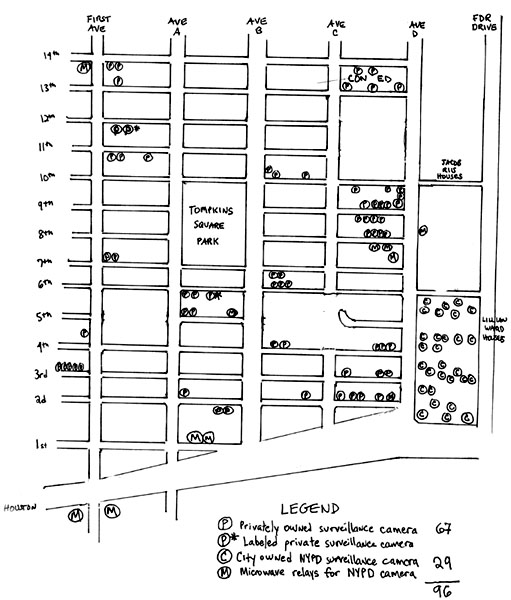
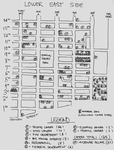
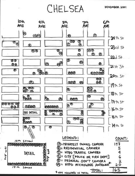
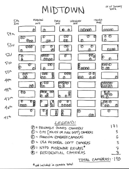
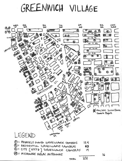
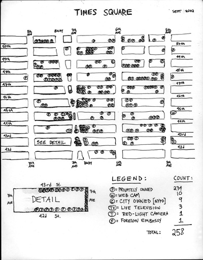
In our first map of the LES, which was made in March 2001, we located a total of 96 surveillance cameras operating in the area east of First Avenue and west of the FDR Drive, south of 14th Street and north of Houston Street ("Alphabet City"). Today, we find that the number of surveillance cameras has risen to 125. Though 125 is a lot of cameras for a single neighborhood, the LES remains one of Manhattan's least surveilled neighborhoods. There are far more surveillance cameras in operation in Chelsea (165), Mid-town Manhattan (190), Greenwich Village (231) and Times Square (258). The only neighborhood we have mapped that has as few surveillance cameras as the LES is Harlem, in which there are "only" 67. And yet both Harlem and the Lower East Side are still portrayed as "dangerous areas," places in which you don't want to walk alone late at night. As we've pointed out elsewhere, this discrepancy shows that surveillance cameras are intended to protect property (not people) and are thus only installed in places where there is property worth protecting.
One of the peculiarities of the LES is that so many of its surveillance cameras are operated by the New York Police Department (NYPD). In 2001, 29 out of the 96 cameras we mapped were operated by the NYPD; today, 42 out of the 125 are police cameras. In the other areas of Manhattan we've mapped, NYPD cameras are far less numerous: there are only 2 near the United Nations, 8 in Times Square, 10 in Chelsea, 5 in Mid-town and 14 in Greenwich Village. The LES would be just like Harlem -- where there is only one police camera in operation (!) -- were it not for the fact that the LES contains the Lillian Wald Housing Development, which is one of the original 10 public housing developments in which the NYPD began installing very extensive video surveillance systems in mid-1997. (Same thing for Greenwich Village. Were it not for the existence of another NYPD "test area" at Washington Square Park, in which there are 11 cameras operated by the police, the area would only have 3 such cameras.)
*
New York City's federally subsidized housing developments are administered by the New York City Housing Authority (NYCHA) and policed by the Housing Division of the NYPD. According to NYCHA's statistics, 94 percent of their residents are either black or Latino, and the average annual income is below $15,000. And so, if these people resent or oppose the installation of surveillance cameras where they live, they simply can't afford to move elsewhere (not when an average NYC apartment costs $12,000 a year to rent!), and so, ultimately, they are forced to tolerate being watched all the time by the police. But these people weren't targeted for maximum surveillance because they are criminals or even the frequent victims of criminals. They were targeted because 1) statistics (success rates, projections and the like) play such an important role in getting, maintaining and increasing federal funding for local authorities like the NYCHA; and 2) statistics are easily misinterpreted, manipulated or even manufactured outright, especially when it comes to statistics derived from the video surveillance of people who both know about the cameras and can't escape from them. (In "the real world," potential criminals generally don't know about the cameras that are watching them, and -- if and when they find out -- can easily move out of their sight.)
In July 1997, a video surveillance system utilizing 105 cameras was turned on at Manhattan's Ulysses S. Grant housing development, in part because it is near the station-house of the 26th Precinct, which is where the police established their VIPER ("Video Interactive Patrol Enhanced Response") unit. Shortly thereafter, a system utilizing 100 cameras was installed at Brooklyn's Albany Houses, with the VIPER unit set up at a near-by station house; and a system using 260 cameras was installed at the South Jamaica Houses in Queens. Because this sprawling housing complex was too far away from the nearest police station to lay down the necessary cables, a unique VIPER unit was constructed on-site.
In each of these CCTV (closed-circuit television) systems, the cables connecting the cameras to the monitors are fiber-optic, which means they provide rapid noiseless transmission; and the monitors display their images "in real time," that is, without skipping any of the 25 frames that go by each second. Everything is recorded. To conserve space, all of the recordings are "time-elapsed," that is, only a frame or two per second has been captured, and each videotape records the feeds from 10 different cameras. If they haven't recorded anything significant, these tapes are re-used after 7 days. Each tape is used a total of 10 times before it is destroyed and replaced with a brand-new one.
According to the NYPD, after the installation of its CCTV systems, the crime rate was reduced at these housing devoplements. But it was possible that these reductions didn't derive from the CCTV systems' effectiveness, but instead from the simple fact that the existence of these systems had been widely publicized before, during and after their installation. And so the NYPD needed the statistics from a NYCHA unit in which the existence of video surveillance wasn't commonly known. In 1998 or 1999, a "secret" system was installed at the Lillian Wald Housing Development, which is located along Avenue D between Houston and 6th Streets. There are at least 26 cameras installed outside the buildings; inside, there are probably another 70 or so cameras watching hallways, laundry rooms, elevators, etc etc. Given the distance to the nearest police stations, it's a good guess that the VIPER unit is located somewhere on the premises.
The system at Lillian Wald was (still) an official secret when we made our March 2001 map, because there (still) weren't any signs that alerted both occupants and visitors to the fact that the police were using video cameras to watch the place. It was only later (the summer or fall of 2001) that the NYPD filled the place with those weird signs, the ones that say that the NYPD is using video cameras to "randomly" watch "selected areas." Instead of reassuring the innocent that they are safe and warning the guilty that their crimes will be recorded, this weird wording has the effect of confusing everybody. Are the police watching or not? Watching this spot, or over there? Watching all the time, or only sometimes? etc etc. These questions lead to other, larger questions. Why bother to post such signs in the first place, unless one's intention was in fact to cause confusion? And, if confusion was in fact the desired effect, why not stick with the signs? Why install any cameras at all? It is unlikely that the NYPD was intentionally trying to re-create the radically uncertain environment that, in Discipline and Punish (1975), Michel Foucault claimed was the essential feature of Jeremy Bentham's "Pantopticon," an 18th century design for the construction of "enlightened" prisons. Nevertheless, that is exactly what the NYPD's weird signs have accomplished; they've turned the Lillian Wald Housing Development into a grim open-air prison for people whose only crime is the fact that they don't have enough money to move out.
Lillian Wald herself would be appalled by these developments. The founder of the Henry Street Visiting Nurse Service and the Henry Street Settlement, she was one of 62 prominent people whose name appeared on a list of subversives drawn up by Woodrow Wilson's Attorney General, A. Mitchell Palmer, who organized the infamous "Palmer raids" on Americans who he thought held "dangerous, destructive and anarchistic sentiments." Like the other people on the list, Lillian Wald had been under government surveillance for years. And so, the installation of police surveillance cameras (and weird signs) at the place named after her subverts and destroys the primary reason for naming something after her in the first place: that is, clearing her good name from false charges that she was an anti-American subversive.
**
When we re-mapped Times Square in September 2002, we not only found that the number of surveillance cameras in the area had tripled in four years, but also that the increase came almost completely from the private sector. Virtually all of the new cameras were privately owned; the police hadn't put up any new ones.
In the new map of the LES, we see something quite different: the growth in private cameras is very slow (71, up from 67), and the growth in police cameras (44, up from 29) is very fast. At least part of these unusual results can be blamed on mistakes made in the original map. Its count of private cameras was too high: five of them were in fact operated by the NYCHA/NYPD and nine others were operated by the New York Fire Department. When corrected, the maps show that private cameras have increased from 53 to 71 (that's more like it!) and police cameras have increased from 34 to 44 (still unusual).
Significantly, all of the new police cameras in the LES are attached to the new police station, which is located at the southwest corner of East 8th Street and Avenue C. Unlike the NYPD cameras at Lillian Wald, which are globe-shaped and are thus easily mistaken for lamps or ornaments, the cameras on the new police station look like surveillance cameras. Perhaps that's why there are no signs informing the public of their existence. By contrast, the old police station on 5th Street -- the one whose facade has been made famous by the detective show NYPD Blue -- didn't have any surveillance cameras attached to it. The "hidden" gesture is clear: this building is the location of a new VIPER Unit or, perhaps, the new location of an old VIPER Unit. Beware.
-- the New York Surveillance Camera Players, 18 November 2002.
"
SCP-New York writes "surveillance cameras in
Manhattan's Lower East Side
Our maps of the locations of surveillance cameras installed in public places in Manhattan were originally designed to find out and then show how many cameras are in operation, and to hazard educated guesses as to the owners of these cameras. But, if these maps are up-dated periodically, they can also be used to document the rates at which new cameras are being installed. And so we have begun to "re-map" certain areas from scratch. We started with Times Square and have now moved on to the Lower East Side.
Formerly a completely immigrant (mostly Jewish and Latino) neighborhood, the Lower East Side (LES) fell prey to speculation and gentrification in the mid-1990s, when it came to be called "the East Village." (Note: there is no "West Village," there's only Greenwich Village, of which the LES has never been a part.) Since the mid-1990s, rents in the LES have increased dramatically, squatters have been illegally evicted and their buildings have been demolished, community gardens have been auctioned off and then destroyed, and gleaming homes, restaurants and "hip" shops for yuppies have been constructed in their places. And yet (fortunately!) the place remains a gritty and relatively undesirable place for yuppies to breed. There is little subway service and the immense Con Edison power-plant on 14th Street and Avenue D -- which has been closed off to the public since 11 September 2001 -- regularly spews poisons into the air.
In our first map of the LES, which was made in March 2001, we located a total of 96 surveillance cameras operating in the area east of First Avenue and west of the FDR Drive, south of 14th Street and north of Houston Street ("Alphabet City"). Today, we find that the number of surveillance cameras has risen to 125. Though 125 is a lot of cameras for a single neighborhood, the LES remains one of Manhattan's least surveilled neighborhoods. There are far more surveillance cameras in operation in Chelsea (165), Mid-town Manhattan (190), Greenwich Village (231) and Times Square (258). The only neighborhood we have mapped that has as few surveillance cameras as the LES is Harlem, in which there are "only" 67. And yet both Harlem and the Lower East Side are still portrayed as "dangerous areas," places in which you don't want to walk alone late at night. As we've pointed out elsewhere, this discrepancy shows that surveillance cameras are intended to protect property (not people) and are thus only installed in places where there is property worth protecting.
One of the peculiarities of the LES is that so many of its surveillance cameras are operated by the New York Police Department (NYPD). In 2001, 29 out of the 96 cameras we mapped were operated by the NYPD; today, 42 out of the 125 are police cameras. In the other areas of Manhattan we've mapped, NYPD cameras are far less numerous: there are only 2 near the United Nations, 8 in Times Square, 10 in Chelsea, 5 in Mid-town and 14 in Greenwich Village. The LES would be just like Harlem -- where there is only one police camera in operation (!) -- were it not for the fact that the LES contains the Lillian Wald Housing Development, which is one of the original 10 public housing developments in which the NYPD began installing very extensive video surveillance systems in mid-1997. (Same thing for Greenwich Village. Were it not for the existence of another NYPD "test area" at Washington Square Park, in which there are 11 cameras operated by the police, the area would only have 3 such cameras.)
*
New York City's federally subsidized housing developments are administered by the New York City Housing Authority (NYCHA) and policed by the Housing Division of the NYPD. According to NYCHA's statistics, 94 percent of their residents are either black or Latino, and the average annual income is below $15,000. And so, if these people resent or oppose the installation of surveillance cameras where they live, they simply can't afford to move elsewhere (not when an average NYC apartment costs $12,000 a year to rent!), and so, ultimately, they are forced to tolerate being watched all the time by the police. But these people weren't targeted for maximum surveillance because they are criminals or even the frequent victims of criminals. They were targeted because 1) statistics (success rates, projections and the like) play such an important role in getting, maintaining and increasing federal funding for local authorities like the NYCHA; and 2) statistics are easily misinterpreted, manipulated or even manufactured outright, especially when it comes to statistics derived from the video surveillance of people who both know about the cameras and can't escape from them. (In "the real world," potential criminals generally don't know about the cameras that are watching them, and -- if and when they find out -- can easily move out of their sight.)
In July 1997, a video surveillance system utilizing 105 cameras was turned on at Manhattan's Ulysses S. Grant housing development, in part because it is near the station-house of the 26th Precinct, which is where the police established their VIPER ("Video Interactive Patrol Enhanced Response") unit. Shortly thereafter, a system utilizing 100 cameras was installed at Brooklyn's Albany Houses, with the VIPER unit set up at a near-by station house; and a system using 260 cameras was installed at the South Jamaica Houses in Queens. Because this sprawling housing complex was too far away from the nearest police station to lay down the necessary cables, a unique VIPER unit was constructed on-site.
In each of these CCTV (closed-circuit television) systems, the cables connecting the cameras to the monitors are fiber-optic, which means they provide rapid noiseless transmission; and the monitors display their images "in real time," that is, without skipping any of the 25 frames that go by each second. Everything is recorded. To conserve space, all of the recordings are "time-elapsed," that is, only a frame or two per second has been captured, and each videotape records the feeds from 10 different cameras. If they haven't recorded anything significant, these tapes are re-used after 7 days. Each tape is used a total of 10 times before it is destroyed and replaced with a brand-new one.
According to the NYPD, after the installation of its CCTV systems, the crime rate was reduced at these housing devoplements. But it was possible that these reductions didn't derive from the CCTV systems' effectiveness, but instead from the simple fact that the existence of these systems had been widely publicized before, during and after their installation. And so the NYPD needed the statistics from a NYCHA unit in which the existence of video surveillance wasn't commonly known. In 1998 or 1999, a "secret" system was installed at the Lillian Wald Housing Development, which is located along Avenue D between Houston and 6th Streets. There are at least 26 cameras installed outside the buildings; inside, there are probably another 70 or so cameras watching hallways, laundry rooms, elevators, etc etc. Given the distance to the nearest police stations, it's a good guess that the VIPER unit is located somewhere on the premises.
The system at Lillian Wald was (still) an official secret when we made our March 2001 map, because there (still) weren't any signs that alerted both occupants and visitors to the fact that the police were using video cameras to watch the place. It was only later (the summer or fall of 2001) that the NYPD filled the place with those weird signs, the ones that say that the NYPD is using video cameras to "randomly" watch "selected areas." Instead of reassuring the innocent that they are safe and warning the guilty that their crimes will be recorded, this weird wording has the effect of confusing everybody. Are the police watching or not? Watching this spot, or over there? Watching all the time, or only sometimes? etc etc. These questions lead to other, larger questions. Why bother to post such signs in the first place, unless one's intention was in fact to cause confusion? And, if confusion was in fact the desired effect, why not stick with the signs? Why install any cameras at all? It is unlikely that the NYPD was intentionally trying to re-create the radically uncertain environment that, in Discipline and Punish (1975), Michel Foucault claimed was the essential feature of Jeremy Bentham's "Pantopticon," an 18th century design for the construction of "enlightened" prisons. Nevertheless, that is exactly what the NYPD's weird signs have accomplished; they've turned the Lillian Wald Housing Development into a grim open-air prison for people whose only crime is the fact that they don't have enough money to move out.
Lillian Wald herself would be appalled by these developments. The founder of the Henry Street Visiting Nurse Service and the Henry Street Settlement, she was one of 62 prominent people whose name appeared on a list of subversives drawn up by Woodrow Wilson's Attorney General, A. Mitchell Palmer, who organized the infamous "Palmer raids" on Americans who he thought held "dangerous, destructive and anarchistic sentiments." Like the other people on the list, Lillian Wald had been under government surveillance for years. And so, the installation of police surveillance cameras (and weird signs) at the place named after her subverts and destroys the primary reason for naming something after her in the first place: that is, clearing her good name from false charges that she was an anti-American subversive.
**
When we re-mapped Times Square in September 2002, we not only found that the number of surveillance cameras in the area had tripled in four years, but also that the increase came almost completely from the private sector. Virtually all of the new cameras were privately owned; the police hadn't put up any new ones.
In the new map of the LES, we see something quite different: the growth in private cameras is very slow (71, up from 67), and the growth in police cameras (44, up from 29) is very fast. At least part of these unusual results can be blamed on mistakes made in the original map. Its count of private cameras was too high: five of them were in fact operated by the NYCHA/NYPD and nine others were operated by the New York Fire Department. When corrected, the maps show that private cameras have increased from 53 to 71 (that's more like it!) and police cameras have increased from 34 to 44 (still unusual).
Significantly, all of the new police cameras in the LES are attached to the new police station, which is located at the southwest corner of East 8th Street and Avenue C. Unlike the NYPD cameras at Lillian Wald, which are globe-shaped and are thus easily mistaken for lamps or ornaments, the cameras on the new police station look like surveillance cameras. Perhaps that's why there are no signs informing the public of their existence. By contrast, the old police station on 5th Street -- the one whose facade has been made famous by the detective show NYPD Blue -- didn't have any surveillance cameras attached to it. The "hidden" gesture is clear: this building is the location of a new VIPER Unit or, perhaps, the new location of an old VIPER Unit. Beware.
-- the New York Surveillance Camera Players, 18 November 2002.
"